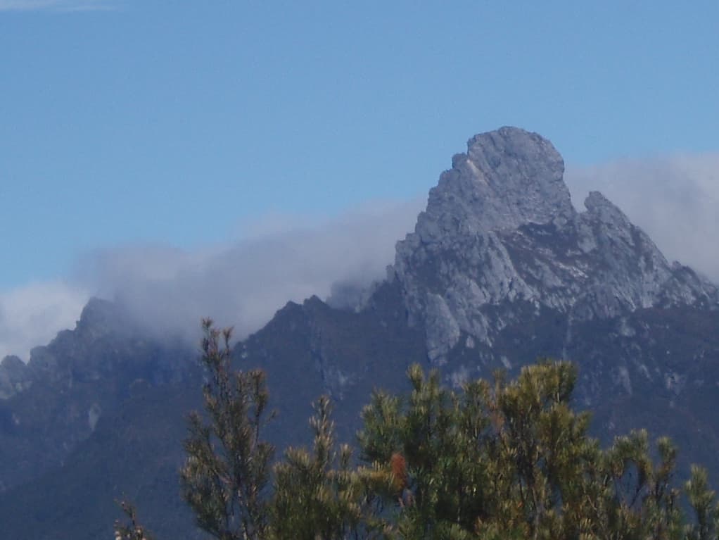

Where Federation Peak sits
Federation Peak reaches about 1,225 metres in the Eastern Arthur Range inside Southwest National Park. The mountain lies within the Tasmanian Wilderness World Heritage Area and forms part of a remote alpine landscape of quartzite ridges and steep cliffs. The summit is a distinct objective from the main traverse because it requires different skills and exposes climbers to severe risk.
Route choices: traverse or summit
The Eastern Arthur Range Traverse is a Grade 5, multi‑day route normally planned as a 6 to 9 day trip, with the walk notes describing roughly 72 kilometres for a standard itinerary. Walkers can start from Huon Campground, the Huon Track or the Farmhouse Creek Track and walk in either direction. The main traverse can be completed without ascending Federation Peak and many parties choose to bypass the summit to reduce technical exposure and risk.
Difficulty and technical requirements
This route is rated Grade 5: only very experienced bushwalkers with specialised skills should attempt it. The summit of Federation Peak involves technical rock climbing and sections with severe exposure. Parks and Wildlife Service Tasmania notes that a fall in those areas is likely to be fatal. Parties aiming for the peak must have rock climbing skills, experience with exposed routes and emergency first aid capability.
Terrain and common hazards
Expect very rough, unmarked track, steep cliffs, exposed scrambles, unstable rock and slippery surfaces. Alpine weather can change quickly: snow, hail, strong wind and sun are all possible at any time of year. Digital navigation alone is unreliable in this terrain, so carry and know how to use a paper map and compass. Rescue in this country can take significant time and in some situations may not be possible.
Campsites, facilities and on‑track conditions
There are no huts or regular services on the traverse. The route has a limited number of campsites: eight formal sites are provided, with a maximum stay of two nights at each. Five of those sites have tent platforms; typical capacity at platforms is three to four tents. Facilities are minimal: there is a toilet at Hanging Lake and parking, water and other amenities at Huon Campground. The whole area is Fuel Stove Only, so open fires are prohibited.
Mandatory registration, passes and group limits
Overnight walker registration is required for this walk and you must also complete the logbook at the trailhead. A valid parks pass is required for entry to Tasmania's national parks. Parks and Wildlife Service manages walker numbers: a maximum of six independent walkers may depart on any given day and the maximum group size is six. These limits exist to protect sensitive vegetation and manage safety.
Essential equipment and recommended items
Pack for alpine and multi‑day conditions. Minimum essentials include a 3 to 4 season tent, sleeping bag and inner sheet (sleeping bag ratings recommended for alpine areas are down to around -10°C), waterproof jacket and over trousers, warm layers, sturdy boots, gaiters, and sufficient food and fuel. The Parks and Wildlife Service recommends carrying a Personal Locator Beacon for life‑threatening emergencies; PLBs can be hired from Service Tasmania offices (Mon–Fri) in Hobart, Launceston, Burnie and Devonport and are available in limited numbers from visitor centres at Cradle Mountain, Lake St Clair and Mount Field. Carry TASMAP 1:50,000 Western Arthur, Hartz and Adamsons map sheets, plus a compass and paper map. On some steep sections parties may need 20 metres of climbing rope to haul packs.
Biosecurity, fire and pre‑departure checks
The Tasmanian Wilderness World Heritage Area is a Fuel Stove Only area and visitors must clean boots, camping gear and vehicles to reduce the spread of root rot and other pests. Before you leave: register for the walk, complete the trailhead logbook, confirm campsite availability and check current park alerts and planned burns. Check the Bureau of Meteorology forecast for alpine conditions and the Parks and Wildlife Service alerts page for local access changes. Be aware that fuel is not available beyond Westerway and that mobile phone reception is patchy in many sections.
Suitability and decision points
This route is only suitable for highly experienced walkers who can navigate in remote alpine terrain, manage heavy packs and, if attempting the summit, climb on exposed rock. It is not suitable for beginners or lightly experienced parties; deaths have occurred on this walk and on Federation Peak. If you are unsure of your skills, consider building experience on Grade 4 routes or choosing shorter, less remote walks.
Emergency planning and on‑route behaviour
Tell a reliable person your plans and record trip intentions in the logbook. Avoid walking alone and be prepared to turn back if the weather or team condition changes. Carry spare batteries, a torch or head torch, a basic first aid kit and insulation for hypothermia prevention. A Personal Locator Beacon offers a way to summon help in life‑threatening situations, but be prepared for delayed rescues in this remote country.
Practical logistics
Access to the start points is via Scotts Peak Road for Huon Campground or by the Huon and Farmhouse Creek tracks. Public transport is not available along Scotts Peak Road and where possible avoid driving reserves at night to reduce wildlife collisions. Buy and study the recommended TASMAP sheets well before departure and make sure all party members can navigate with map and compass.