Don

Don (sometimes known as the Don) is a small village, located just outside Devonport, situated on the Don River. It is home to the Don River Railway and the Don Village Market. It is often bypassed, seen as little more than a name of the map on the outskirts of Devonport, but it was not only settled and estabished as a port before Devonport, it played a much greater role than it neighbour in the early days of white settlement on the Coast.
Don Reserve is a narrow strip of remnant vegetation from end Best Street to the River on the eastern bank of the Don River. It forms a peaceful and stunning bushland reserve which features paved and sawdust walking tracks near and beside the Don River. It is accessible seven days a week. A fauna survey in 2002 recorded nine mammal species the Reserve including echidna, Eastern Barred Bandicoot, southern brown bandicoot, brush-tailed possum, ring-tailed possum, long-nosed potoroo, Tasmanian pademelon, Bennett’s wallaby and swamp rat. In 2014, platypus were recorded in the Don River near the southern end of Waverley Road.
The Reserve is centred around the Don River, which rises in West Kentish near Sheffield and flows generally north into Bass Strait at Devonport. The river descends 343 metres over its 37.8-kilometre course.
Don River Railway
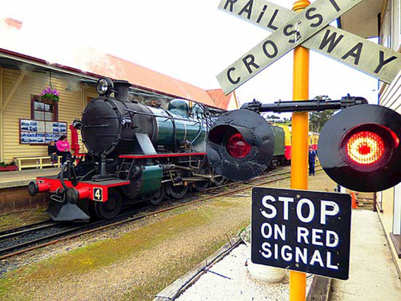
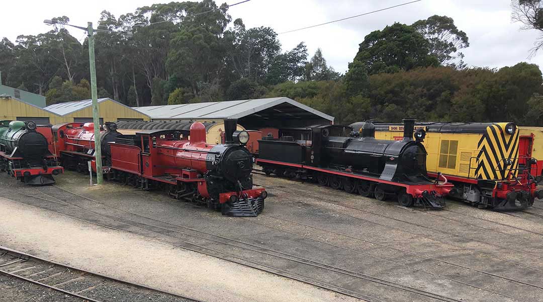
Located on the outskirts of Devonport at the village of Don, The Don River Railway is one of the most enjoyable railway museums in Australia. Its focus is Tasmania's trains of yesteryear, and its sizeable display includes steam and diesel engines and other rolling stock that have played an important part in Tasmania's rail history. The extensive workshop is open for visitors to wander around and see trains in various stages of restoration. Don't miss the leisurely tourist train ride along the banks of the Don River to Coles Beach.
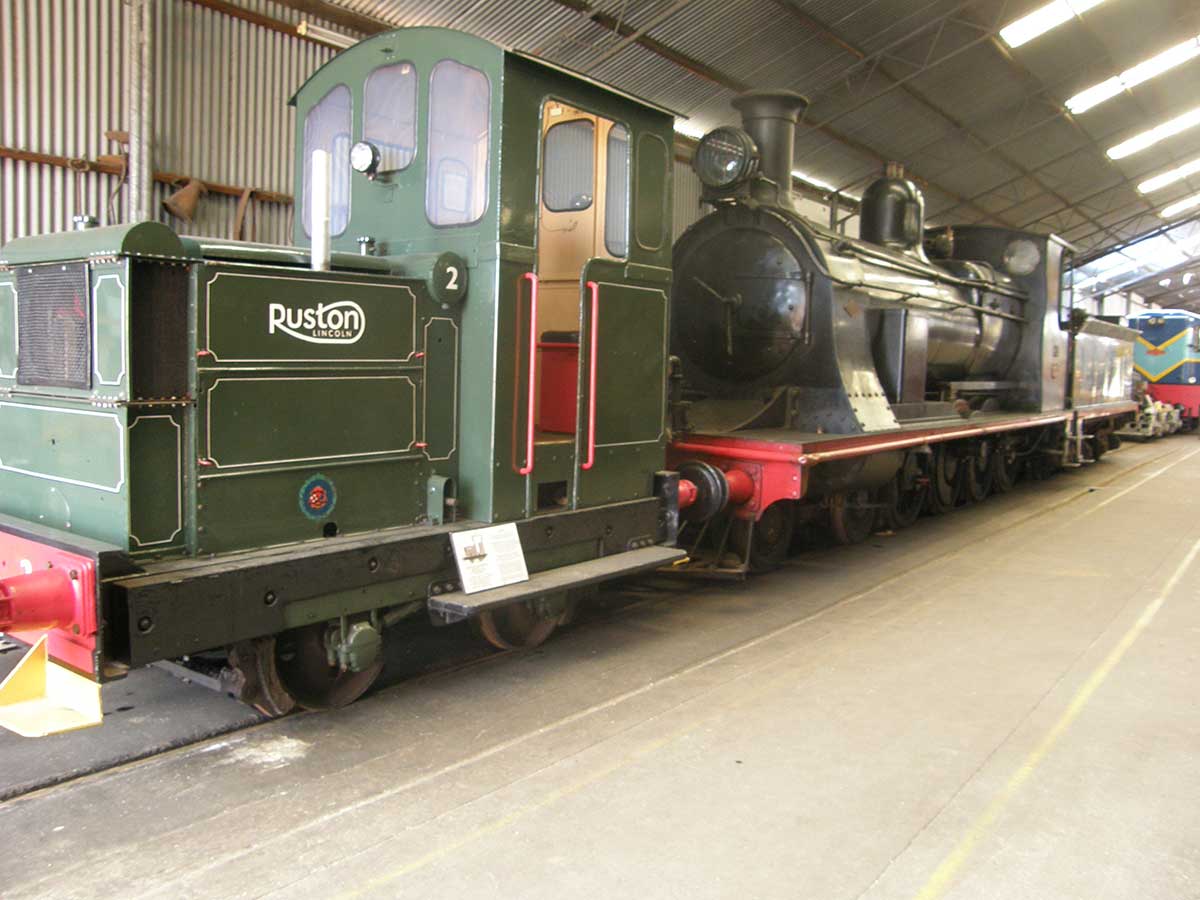
The Don River Railway came about because of the hard work of the volunteer Van Diemen Light Railway Society in 1973, and they secured the remaining 3.5 km section of track between Don Township and Don Junction. Today the Don River Railway takes visitors on a scenic ride along the banks of the Don River to Coles Beach. The half hour return trip operates every Thursday, Friday and Saturday by a vintage 1944 railcar, except for Sundays when the train is hauled by a restored 1951 M4 type 4-6-2 steam locomotive.
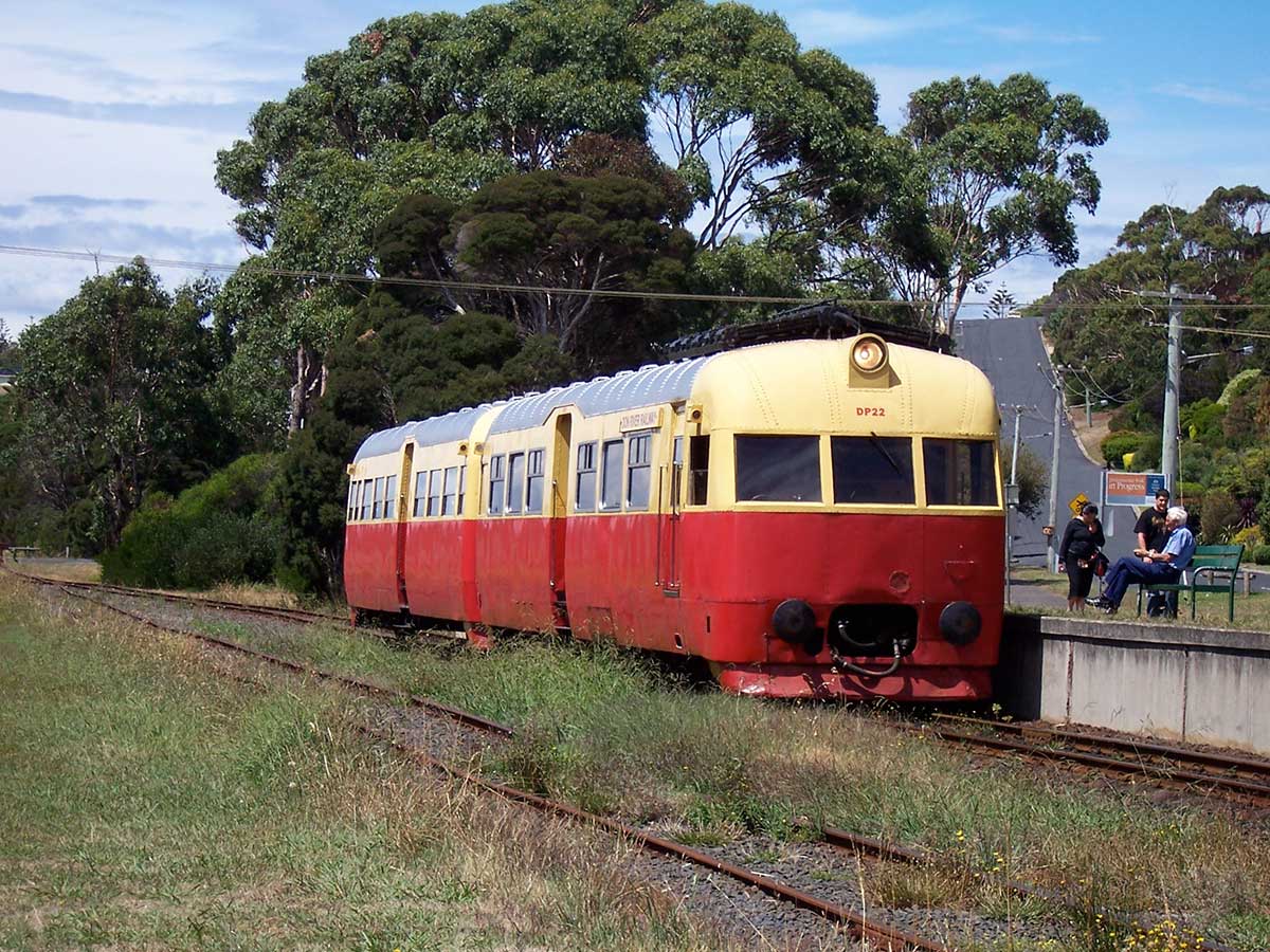
The journey itself is pleasant and departs from a fully restored railway station that originally stood in Ulverstone before being brought to the museum's site at Don Township. It follows the banks of the Don River, winding through some picturesque parkland before arriving alongside Coles Beach at Don Junction. There is ample time to enjoy a pleasant coastal walk for those who prefer to alight and return on the next train, or you can simply hop off and watch the train uncouple, run-around on the reversing loop and couple to the other end for the return journey.

Don Heads
Don Heads
Don Heads, on the western side of the mouth of the Don River, is a rocky headland peppered with columnar basalt rocks along its shore. A walking trail leads to the top of the bluff and along the coast to a number of beaches, and eventually Lillico Beach Conservation Area.

Several basalt flows created the unusual coastal landforms seen at Dons Head. The Tertiary basalt headland has been eroded by wave action, leaving a sea stack on the shore platform with columner jointing, ultramafic xenoliths (olivine) in boulders on the beach with polygonal jointing, pillow lavas, sea caves and sea potholes. In some places lava from one flow fills cracks in the flow beneath.
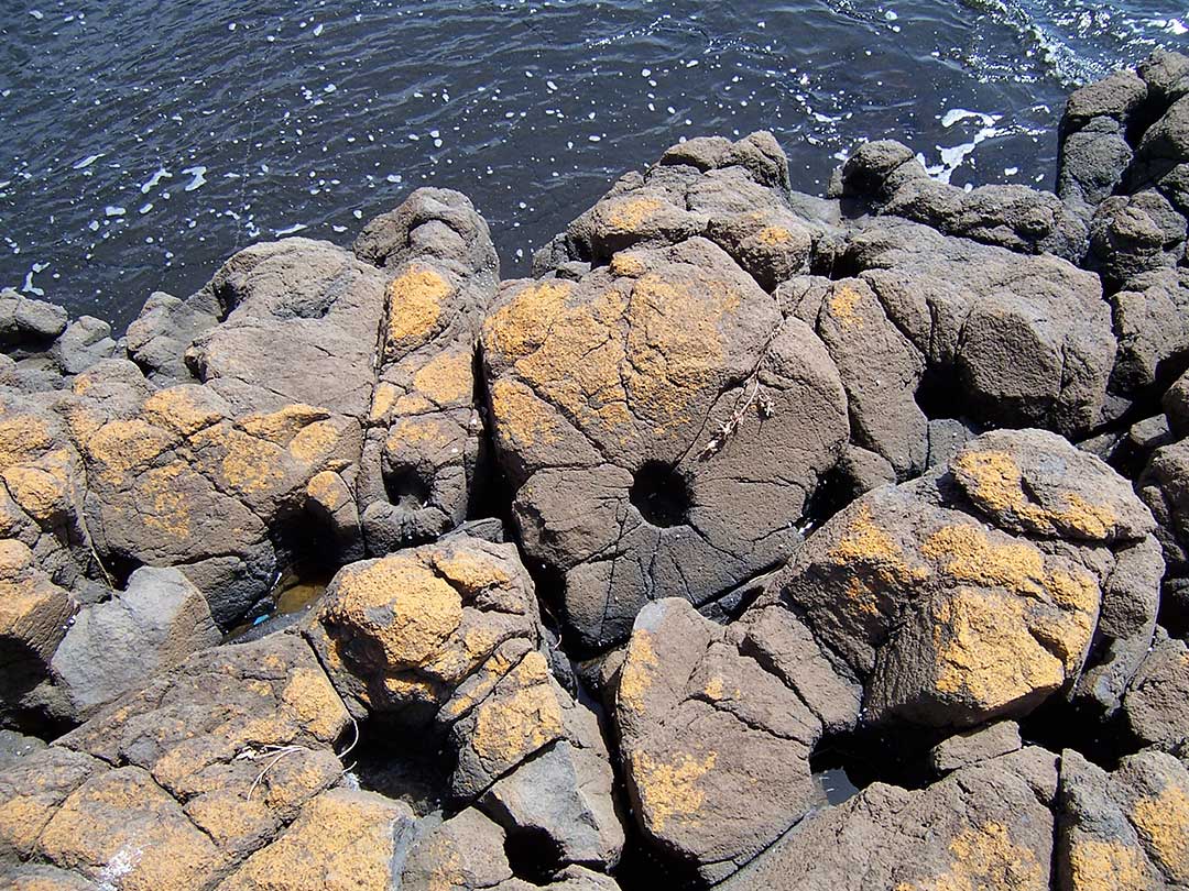
Columner basalt weathers like a tesselated pavement, giving rise to high rimmed polygonal pools and depressions.

Don Heads beach is a cobble recurved spit which is attached at its western end to the base of the 50 m high heads, and curves to the southeast for 200 metre into the entrance to the river. Nearby is 2 ha wetland, which is encircled by the Don Heads Nature Trail. The narrow cobble ridge is fronted by 100-200 m wide intertidal rock flats. Don Head is accessible by car from the Don Heads Road.
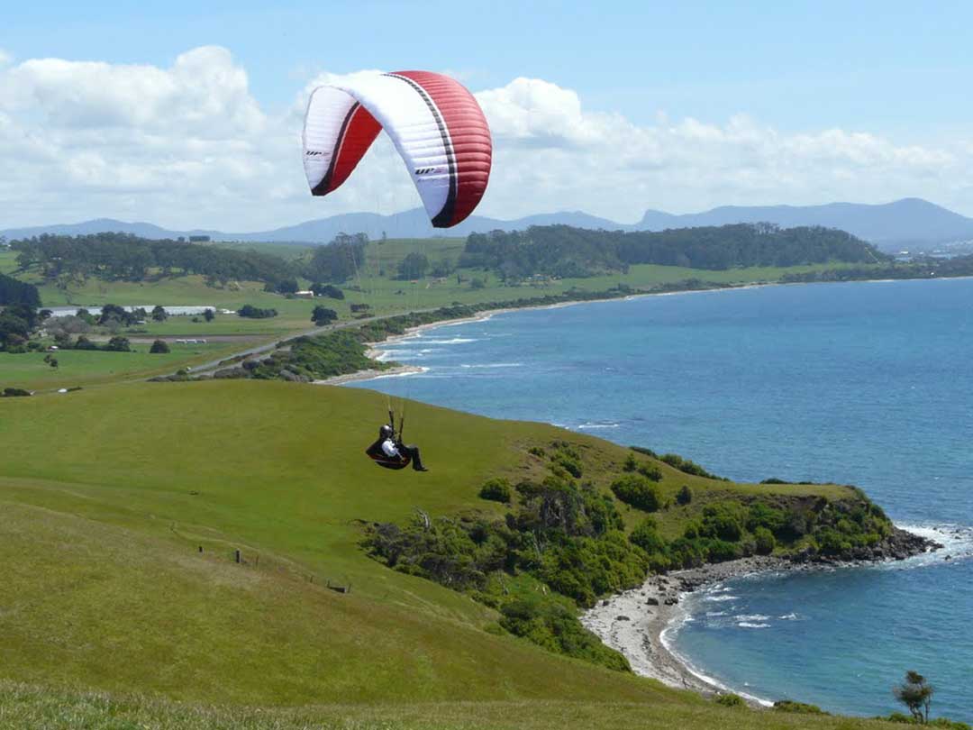
Paragliding above Don Heads
Coles Beach, Devonport
Coles Beach is on the eastern side of the Don River adjacent to Don Heads. Accessed via Coles Beach Road, Coles Beach is another very popular spot for beachgoers. Nearby facilities include public toilets, sealed walking and cycling track, electric barbecue, picnic shelters, car park and an outdoor shower. Coles Beach is located in a semi-circular north-facing bay, bordered by a low cobble point to the west and 20 m high bluffs to the east.

Coles Beach, Devonport
The Coles Beach Road and the railway line to Burnie run parallel to the back of the beach. There is a large reserve and car park toward the western end and a second car park at the eastern end. The beach is moderately well exposed to west through northerly waves and is a popular surfing beach. At high tide it consists of a steep, narrow sand and cobble beach, while at low tide a 100 m wide, continuous bar is exposed, with rock flats, including some large boulders to either end. During higher waves rips form in the lower surf zone. Coles Beach's rocky shoreline make it an ideal place to go beachcombing for shells and small sea creatures.

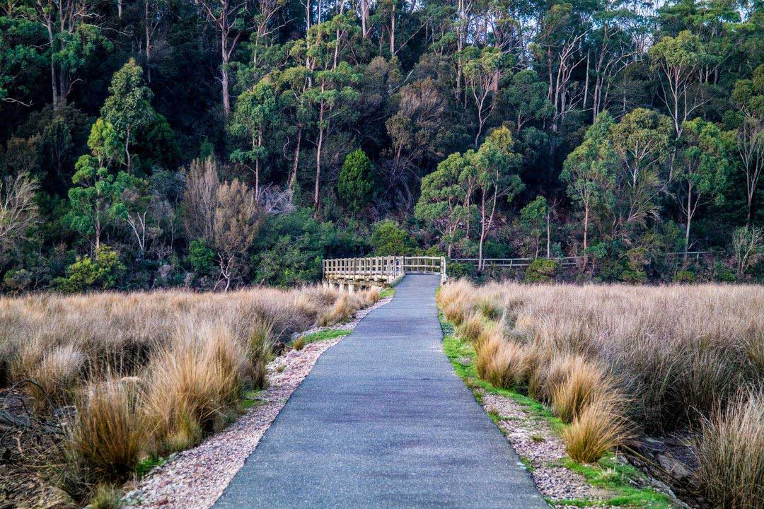
Don to Devonport Cycleway
The Don to Devonport Cycleway is a 7.5km, grade 2 One Way hike located in Northern Tasmania Tasmania. The hike should take approximately 2hrs to complete. See some of the nicest parts of Devonport by walking or cycling the rail trail. Parts of the trail run parallel with the railway to Burnie and the Don River tourist railway. Part also follows the route of a former tramway. You can follow the trail from the Don Railway Station to central Devonport, with the option of a loop trail along the opposite bank of the Don River.
Naming the River Don
It is generally believed it was named after the River Don in South Yorkshire, England, by Henry Hellyer, surveyor for the Van Diemen's Land Co. when he passed through the area in 1826. This name may have been chosen because a number of the Company's pioneer settlers were from villages on the River Don in South Yorkshire. Another source suggests it was named after the River Don in Aberdeenshire, Scotland. This may be because the river flows through the locality of Aberdeen, near Spreyton. The Scottish settlers who named Aberdeen may have done so believing the River Don had been named after Scotland's River Don, which flows through Aberdeenshire, Scotland, when in fact it was named after the English River Don.
History of Don
Don, now part of the City of Devonport, is today known as the home to the Don River Railway and the Don Village Market. Many of today's travellers through the small township would find it difficult to believe that it was once a thriving pioneer settlement. There is a very hackneyed phrase which is often used to express commencement - "the cradle". However, in this particular instance it is an appropriate description, for indeed it was literally the cradle place of hundreds of early Tasmanians.
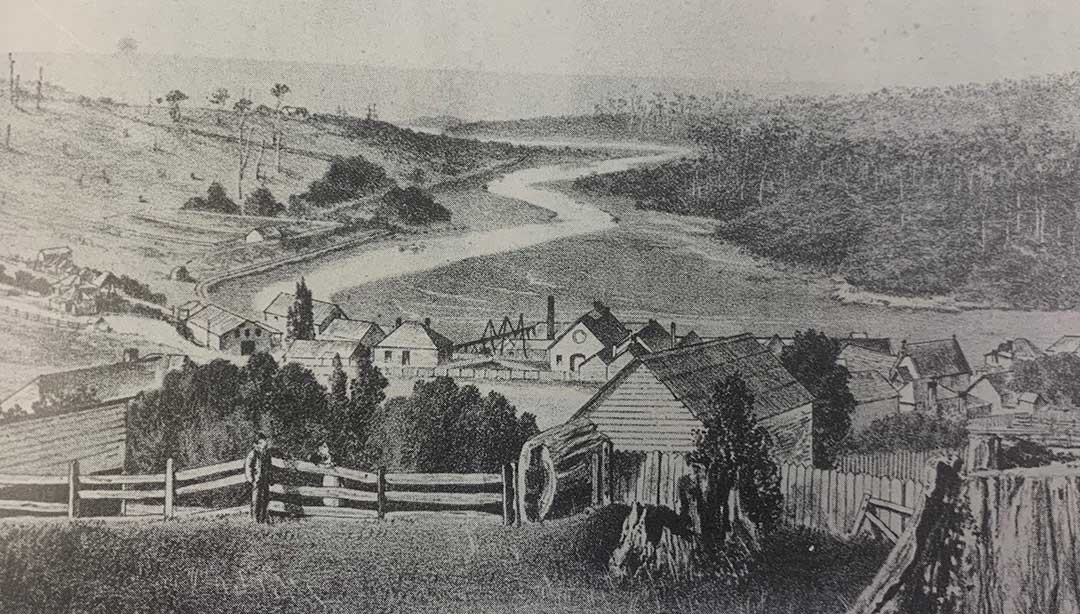
Don village in 1880
Don came into being because of timber, or more correctly because of the very many people of diverse character who worked together in a spirit of rare co-operation to harvest the timber. In 1854 a large sawmill was built and operated by Canadians Messrs Cummings and Raymond, who came from Ottawa and Nova Scotia respectively. They built tramways into the forests to bring out the timber; built and bought vessels in which to ship it; built railway lines and bridges; established a trading store, furniture and joinery factory, butchery and bakery; built a school and a church, all of which soon attracted many settlers.
As the land was cleared of timber, it was rented to tenant farmers after an initial rent free period to allow them opportunity to get on their feet. The trading store allowed credit from crop to crop, and purchased the produce which tenants had in excess of their need, e.g. butter.
Working for the Company were coal miners, timber workers, sawyers, craftsmen of all kinds, ship builders, captains and crews, clerks, and navvies capable of every conceivable task. The Company built dozens of small cottages to house them, which were let to them for reasonable rentals.
The Church built by the Company and the community became Don's hub, cared for the whole district spiritually, emotionally, and culturally, regardless of country of origin, previous church allegiance, or social origins of its inhabitants. The widowed or orphaned were fed; the numerous bereaved comforted; and entertainment provided for their limited leisure time. Tea meetings and concerts were held for every imaginable reason and always well patronised. In return the church expected, but did not always obtain, a strict moral behaviour and loyalty to the congregation.
The settlement was fortunate in that successive sawmill managements continued the same community oversight as their predecessors. John Henry had the same philosophy and concern for his fellow men when he took over the Company in 1873. Misbehaviour by exuberant youth in the rear of the congregation or back seats of a concert was admonished on the spot by the Chairman or Minister. Sport for healthy bodies and Temperence Societies and educational lectures for healthy minds was encouraged.
Cynics may doubt the motives of those community leaders, but times weren't easy and the Cummings and Raymond partners were continually under financial stress and ultimately experienced bankruptcy, and John Henry had his own problems when the Van Diemen's Land Bank collapsed.
The mutual sense of responsibility for each other's welfare raised a community with a strong character which coped with the inevitable droughts, floods, bushfires, and disease. And because of the community oversight they did not experience abject poverty as did many other areas. For example, the children of one resident addicted to the bottle, were watched over and often fed by the nearby baker.
It took the arrival of the Railway in Formby [Devonport] and the burning down of their sawmill for the third time, to eventually
cause the decline in work, and of course, in population. The removal also of the sand bar from the mouth of the Mersey River enabled the entry of larger vessels, which together with the Railway made it a rrore viable port than the adjacent River Don. John Henry moved his Company to Devonport, and other tradesmen did likewise.
- Faye Gardam. Reprinted from Tasmanian Ancestry, Vol. 9, No. 2, 1988. The Geneoloical Society of Tasmania. Inc.