


Devonport

Devonport, at the mouth of the Mersey River, is one of three major cities in Tasmania's north, the others being Launceston and Burnie. To visitors to Tasmania, it is primarily known as the port for the Spirit of Tasmania car and passenger ferries - Spirit of Tasmania I and II - which make daily 10-hour trips between their terminals at East Devonport and Station Pier, Melbourne.

Devonport is seen by many as a way station, not only for people travelling between Tasmania and the mainland but for travellers on the north west coast of Tasmania, though there is plenty in the Devonport region for visitors to see and do to justify more than an overnight stop upon arrival or before departure.
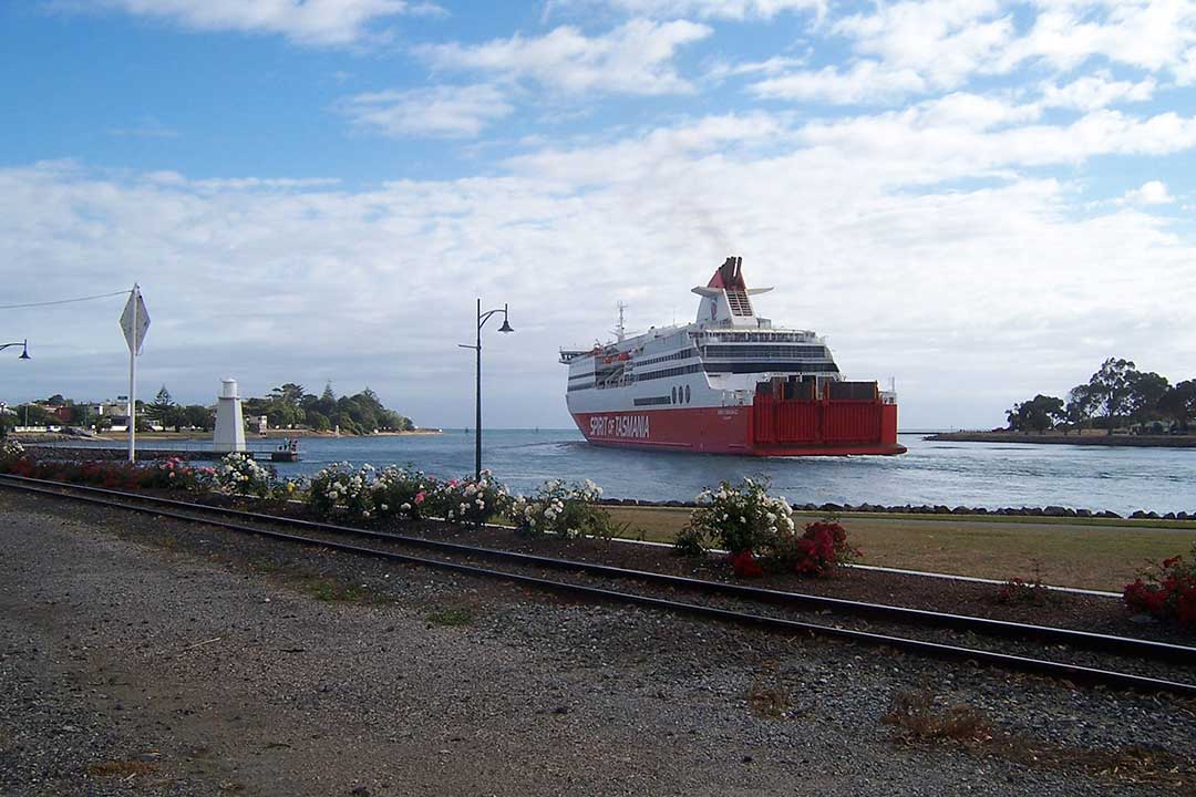
Devonport is an active seaport that handles much of the movement of produce from the farms and fisheries of Tasmania. With over 23,000 people, the City of Devonport is the largest population centre on the northern coast of Tasmania. Devonport Airport is located at Pardoe Downs approximately 7 km to the east of the city of Devonport, about a 15 min drive by car. The airport is serviced by Bombardier Dash 8 turboprop aircraft, operated by QantasLink, with four daily services to Melbourne, Victoria.
There are several bus companies serving Devonport including Mersey Link, Redline Coaches and Phoenix Coaches. Metropolitan Devonport bus services are limited on Saturdays and there are no services on Sundays or Public holidays.
Where Is it?: Devonport is 102 km north west of Launcestion via Bass Highway, 47 km east of Burnie and 277 km from Hobart. It is a sea port on Bass Strait

Around Town
The main Central Business District (CBD) is on the west side of the Mersey River and includes a pedestrian mall, cinema, speciality stores, chain stores such as IGA and hotels. There are several local restaurants and cafes.
Local theatre and Conventions are held at the Devonport Entertainment and Convention Centre in the city's CBD.
The Devonport Regional Gallery evolved from the inception of The Little Gallery, which was founded by Jean Thomas as a private enterprise in 1966. The Gallery presents an annual program of exhibitions, education and public programs including events and workshops. A broad range of selected local artisan works are displayed at the North West Regional Craft Centre and gift store in the CBD.
There are walking tracks along the coast from which to enjoy nature, or to take an early morning walk and watch the Spirit of Tasmsnia come in from Melbourre. To the west of Mersey Bluff is Don Heads. Tiagarra, the Tasmanian Aboriginal Cultural and Arts Centre, has dioramas showing the lifestyle of the Tasmanian Aborigines from the region, and is close to Aboriginal rock carvings.
Mersey Bluff
Mersey Bluff is an interesting coastal area featuring cliffs, seascapes, parkland and Aboriginal rock art. Mersey Bluff is composed of Jurassic dolerite (approximately 180 million years old). In places exposed surfaces display unusual markings that were once believed to have been carved by Aboriginal people. However these are now considered to be a result of weathering and root action.

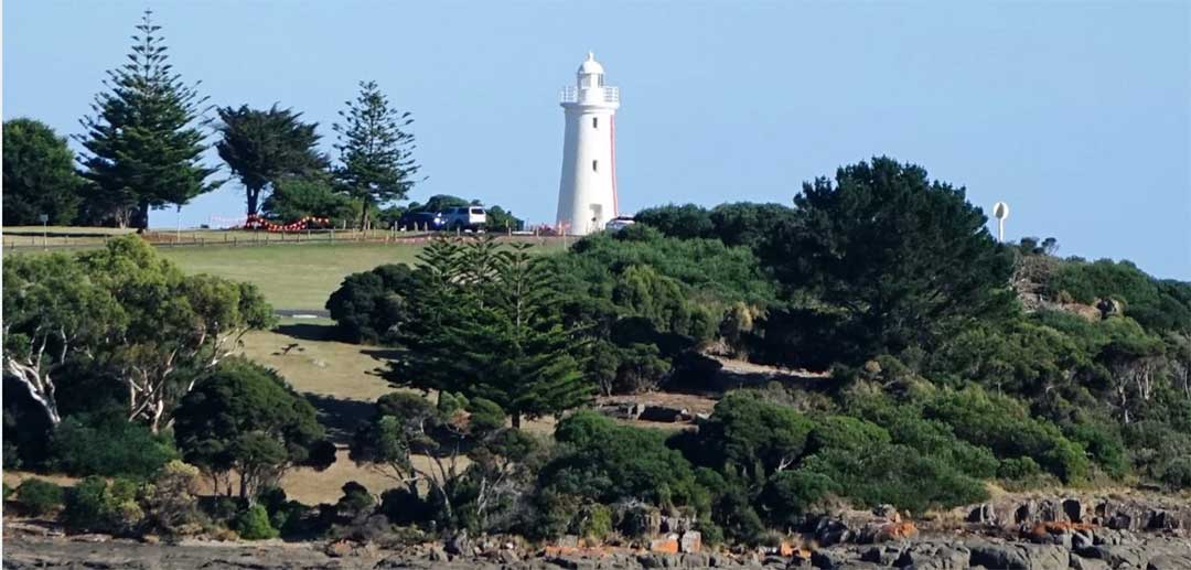
The Mersey Bluff Lighthouse standing at the mouth of the Mersey River near Devonport is unusual in Australia with its distinctive vertical red striped day mark. Established in 1889 and is built of bricks on a stone base, it replaced a succession of beacons and obelisks that had formerly stood on the site. It also replaced the earlier Don River light. The establishment of the lighthouse ended a history of wrecks in this area.

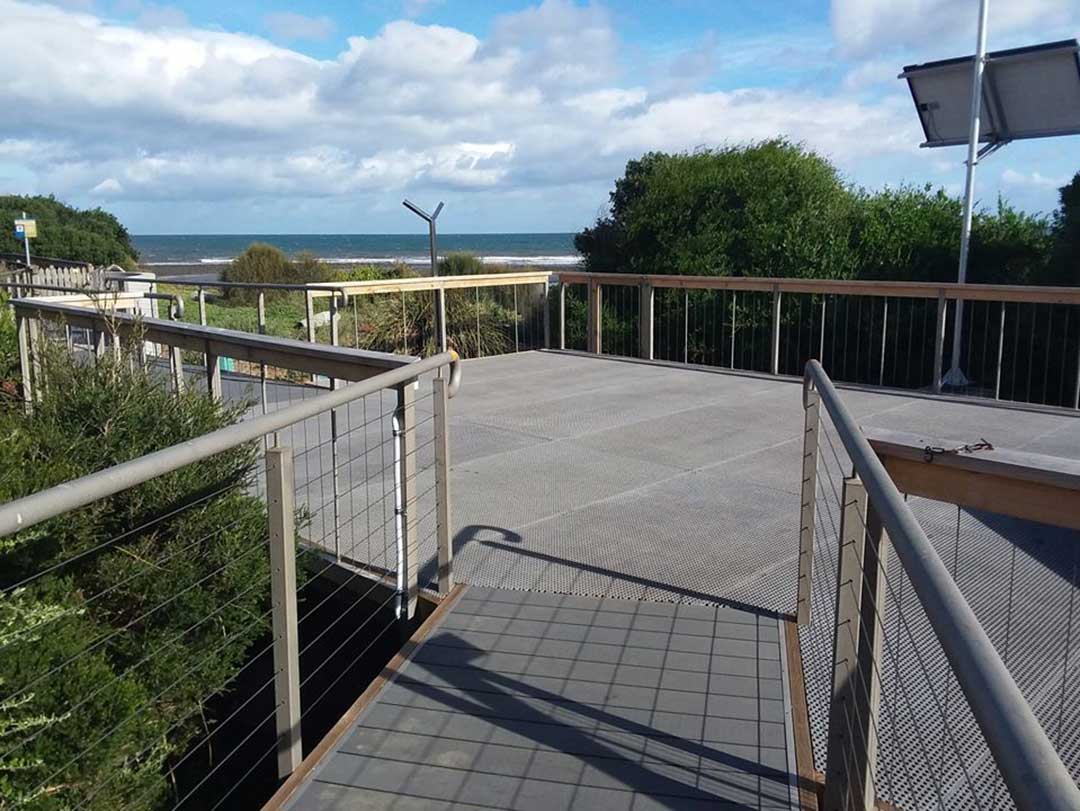
Accessed via Bluff Road, the Mersey Bluff Beach is the only beach in Devonport patrolled by volunteer surf lifesavers (summer months only). Located in the iconic Mersey Bluff Precinct, this beach is a popular spot for residents and holiday makers. A kiosk is located nearby, as is a children’s playground. Other nearby facilities include public toilets and change rooms, sealed walking and cycling track, electric barbecues, picnic shelters, car parks, skateboard facility and sports ground.

Don to Devonport Cycleway
The Don to Devonport Cycleway is a 7.5km, grade 2 One Way hike located in Northern Tasmania Tasmania. The hike should take approximately 2hrs to complete. See some of the nicest parts of Devonport by walking or cycling the rail trail. Parts of the trail run parallel with the railway to Burnie and the Don River tourist railway. Part also follows the route of a former tramway. You can follow the trail from the Don Railway Station to central Devonport, with the option of a loop trail along the opposite bank of the Don River.

Back Beach, Devonport
Accessed via Coles Beach Road, located to the west of Bluff Beach. Nearby facilities include cycle and sealed walking pathways, rubbish bin, car park and foreshore reserve area. Back Beach is also a designated dog exercise area.

Coles Beach
Accessed via Coles Beach Road, Coles Beach is another very popular spot for beachgoers. Nearby facilities include public toilets, sealed walking and cycling track, electric barbecue, picnic shelters, car park and an outdoor shower. Coles Beach is located in a semi-circular north-facing bay, bordered by a low cobble point to the west and 20 m high bluffs to the east.
The Coles Beach Road and the railway line to Burnie run parallel the back of the beach. There is a large reserve and car park toward the western end and a second car park at the eastern end. The beach is moderately well exposed to west through northerly waves and is a popular surfing beach. At high tide it consists of a steep, narrow sand and cobble beach, while at low tide a 100 m wide, continuous bar is exposed, with rock flats, including some large boulders to either end. During higher waves rips form in the lower surf zone. Coles Beach's rocky shoreline make it an ideal place to go beachcombing for shells and small sea creatures.

Don Heads, Don
Don Heads, Don
Don Heads, on the western side of the mouth of the Don River, is a rocky headland peppered with columnar basalt rocks along its shore. A walking trail leads to the top of the bluff and along the coast to a number of beaches, and eventually Lillico Beach Conservation Area.

Don Heads beach is a cobble recurved spit which is attached at its western end to the base of the 50 m high heads, and curves to the southeast for 200 metre into the entrance to the river. Nearby is 2 ha wetland, which is encircled by the Don Heads Nature Trail. The narrow cobble ridge is fronted by 100-200 m wide intertidal rock flats. Don Head is accessible by car from the Don Heads Road.
Kelcey Tier Nature Walk
160 hectares of native bushland which abounds with many varieties of birds, skinks and wildflowers. Discover the sculpture 'Preeatenna', which means 'lizard' in the Tasmanian Aboriginal language, reinforcing the important Aboriginal cultural links to the area. Read the message on the Peace Pole, and take in the views of Devonport and the Mersey River Estuary. The circuit walk is 3.6km and takes 1.5 - 2hrs. Maps are available from the Devonport Visitor Centre.
Location: top end of Durkins Rd, off Stony Rise Rd, Devonport.
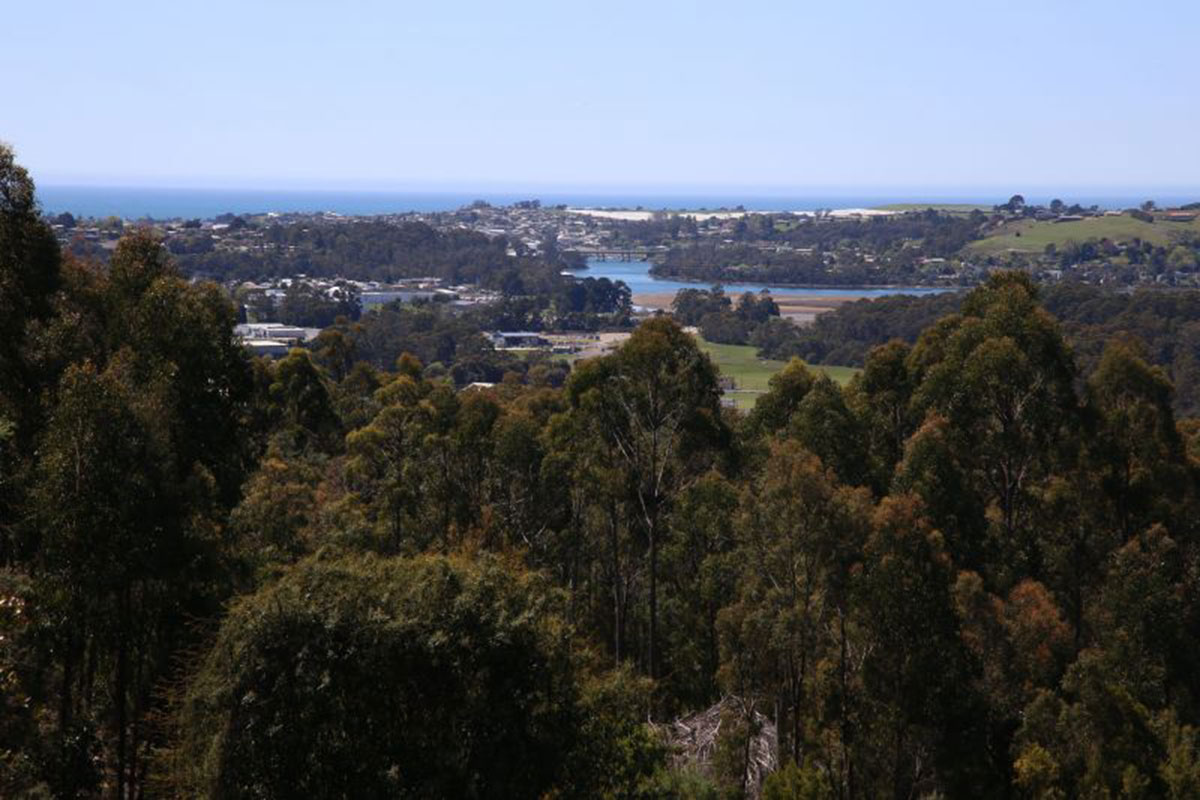
The Mersey River
The city of Devonport is situated at the mouth of the Mersey River on Bass Strait. The River was marked on early maps as the Second Western River, the first being the Forth River. It was in 1826 that its name was bestowed by Edward Curr, the chief agent for the Van Diemen's Land (VDL) Company, naming it the River Mersey after the river that flowed through his hometown of Sheffield, England. Van Diemen's Land (VDL) Co.'s agricultural adviser, Alexander Goldie, had completed a whaleboat journey with surveyor Joseph Fossey at Curr's request to examine the coastline and its rivers from the Mersey River to Cape Grim in the winter of 1826. It is likely that Goldie had named the river something else in his report, but as it was the most significant river that he had found, Curr decided its name should recall the river of his birthplace.
Lt-Gov. Geoege Arthur camped overnight on Mersey Bluff during an exploatory trip through the area in 1829, and named the estuary of the broad and sheltered river Port Frederick, after his nephew. The name never caught on, though it remained on many maps published in the 19th century.
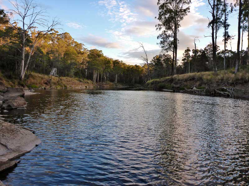
The Mersey rises in the lake district near Mount Pelion East on Tasmania's Central Plateau. Fed by the Dasher and Fisher rivers, it flows 146 km north, east, and again north before entering its estuary at Latrobe, the head of navigation, and emptying into Bass Strait at Devonport. The stream cuts a gorge up to 600 metres deep into the face of the plateau, where its steeply falling water is harnessed for hydroelectric power. The Mersey is linked with the Forth and Wilmot rivers and supplies water from its main storage reservoir, Lake Rowallan (1968), to hydroelectric-generating plants on the Forth. The Mersey flows through a timber district before entering its lower valley, which supports dairying, sheep raising, and fruit and potato farming.
The Mersey River is one of the best river fisheries in Tasmania. Anglers will particularly enjoy fishing the fastwater sections downstream from Lake Parangana to Dynans Bridge, the rural flats at Kimberley and Merseylea and the estuary at Latrobe.
While brown trout are dominant, rainbow trout are common in the middle reaches and sea run trout are a feature at Latrobe and the estuary. At Croesus Cave (Olivers Road), the river flows through the pristine Mole Creek Karst National Park for a distance of around 2 km. Bait fishing is not permitted within National Parks. A valid pass is required for entry to Tasmania's National Parks and must be displayed on vehicles and boats. Parks Passes are available for purchase from the Mole Creek Visitors Centre.
Beyond Devonport

Tasmanian Arboretum
Wander through a peaceful landscape among trees from ancient times in this unique 66 glorious acres of botanical Tree Park. Follow our walks and nature trails or sit quietly and watch the waterbirds and platypus. Entry by donation. 9am to sunset. 03 6427 2690. Location: Old Tramway Road, Eugenana, 10km south of Devonport.

Lillico Beach Conservation Area
6km west of Devonport alongside the Bass Highway, Lillico Beach Conservation Area is a beautiful spot during the day (coastal bush with pebbles, rocks and a boardwalk, but no sand) and wonderful around dusk when a colony of fairy penguins come in for the night. Between October and April, volunteer guides are on hand to provide information and use red light torches so visitors can see the penguins clearly from viewing platforms.
The highlight of the viewing experience is seeing the little penguins emerge from the sea and make their way over the rocks and up the beach to their burrows. The walkway is wheelchair friendly. Unlike the more well-known fairy penguin parade on Phillip Island, Victoria, access to Lillico Beach's penguin parade is free. A donation box is provided to enable this service to continue.