Burnie History: Birth of a City
Burnie: The First 50 Years
Approval was given for the establishment of its port at Emu Bay by the Van Diemen's Land Company in 1827. This included the construction of jetty, a store on Blackman's Point near the jetty. In May 1827, Hellyer supervised the construction of the jetty, a crane was installed to lift goods from the boats, a store, sawpit, and a few huts. they were built on the company's 15,000 acre Emu Bay property which extended from Emu Bay to Cam River.
Work was then commenced on the construction of a road, between 18-20 feet wide, from the little settlement to Surrey Hills, an inland area selected as a suitable place for the Company's sheep to graze. The road work employed five men, constructing a muddy track through the dense coastal rain forests. This route generally follows what is now Marine Terrace, Mount Street, Ridgley Highway (Old Surrey Road) as it travels through Romaine, Ridgely, Highclere and on to Hampshire, a distance of around 30 km.
With the completion of this inland route by the end of 1828, the transport of personnel, livestock and equipment from the coast was possible. The Surrey Hills Road road was later linked to a livestock track from Mole Creek and a bridle track along the coast from Emu Bay to Circular Head.
By the time of the road's completion, the first ten indentured servants from Britain had arrived in Emu Bay. Their skills were diverse, including sawyers and carpenters, a blacksmith, farm servants and brick layers. The Company also received assigned convicts to be used for splitting timber, fencing, shingle-splitting and rough building. The combination of the indentured servants and the assigned convicts formed the nucleus of the first company settlement. A handful stayed at Emu Bay, the rest were sent inland to prepare the tracts of farmland at Hampshire and Surrey Hills.
A year on, and the settlement at Emu Bay had changed little, five cottages, a blacksmith's shop and a sawpit were the only buildings to be added. What is now Oakleigh Park had been quickly cleared to cultivate potato and wheat (6 acres). It became the site of the Van Diemen's Land Company's headquarters from 1875 to the early 1950's and later, the centre of early port activity when Burnie became the headquarters for the road and rail system in this part of Tasmania.
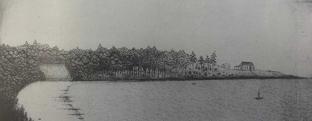
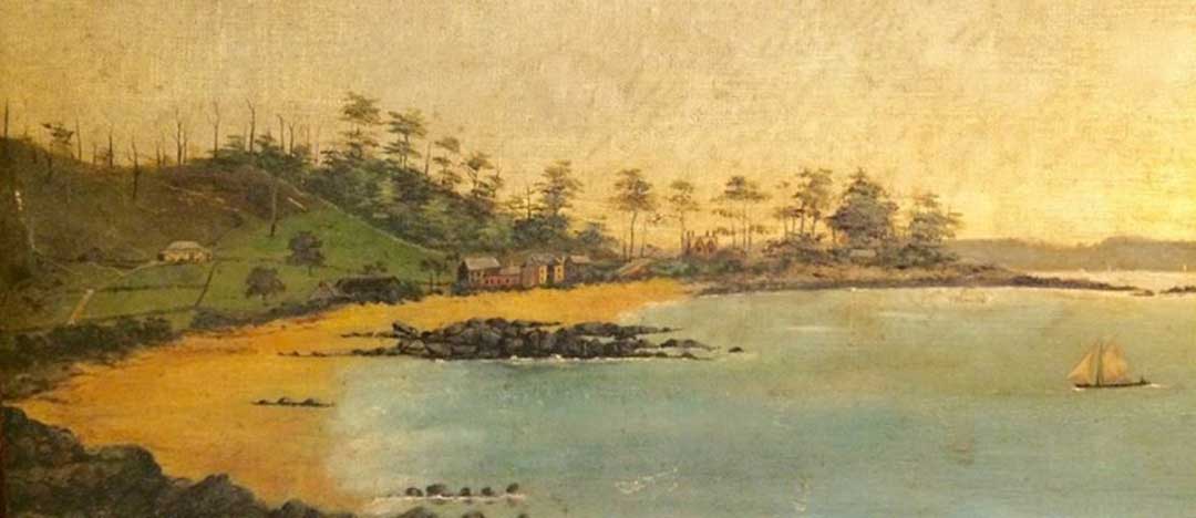
A sketch of Emu Bay by the VDL Co.'s surgeon, Dr John Hutchinson, in 1828, soon after the first buildings had been erected.
In 1828, John Helder Wedge, a surveyor appointed by the Government to report on the VDL land concessions advised the Government to reserve land at Emu Bay for an official township as Emu Bay, Circular Head and Cape Grim were the only possible shelters for shipping on the northwest coasts. The report was not adopted.
The thick rainforest surrounding Blackman's Point was all but impenetrable, restricting clearing to what was only absolutely necessary. No town plan existed, there were no formalised roads, only a rough track linking the few buildings (it would later develop into Marine Terrace), nor were their plans to develop the tiny port further.
For the hills station it was a somewhat different story. By 1831, Hampshire Hills had a superintendant's cottage and garden, store and office, nine cottages, a barn, stables, cattle sheds, pig styes, stockyards and about seven miles of fencing.
The attempt to use the Surrey and Hampshire Hills native grasslands for grazing sheep proved a colossal blunder, with thousands of expensive imported sheep dying from cold. By 1833 the blocks were virtually abandoned and only a few cattle stockmen remained at Emu Bay.
The original overland route to our North West Coast opened up by Van Diemen's Land surveyors Henry Hellyer and Joseph Fossey in 1827-28 also proved to be a disaster. Passing behind Mount Roland, it was so incredibly steep in several places, bullock teams pulling wagons couldn't climb it. Through the 1830s several surveyors, including Joseph Ring (later Town Surveyor for Hobart), searched for an alternative route to the West. All failed to find a way to cross the deep ravines of the Forth Valley.
Edward Curr, manager of the VDL Co believed it would be easier to attract settlers if Emu Bay was connected by road to the other Tasmanian settlements, and offered to jointly fund another attempt to find a better route to Emu Bay with the government. Surveyor-General Robert Power, who had the responsibility to open roads to every new settlement, was in the middle of negotiations with Curr when the 43 year old Nathaniel Lipscomb Kentish arrived from South Australia looking for a job. Having impressive credentials endorsed by Governor Gawler of South Australia, Power appointed him to his Survey Department on 18 November 1841. Kentish had been the Surveyor of Roads and Bridges in charge of constructing part of the Great Western Road over the Blue Mountains to Bathurst in New South Wales, with nearly 1000 convicts under his supervision.
It would soon become a decision Power would greatly regret. What the Surveyor-General didn't know at the time, was that the egotistical Kentish possessed a personality trait that compelled him to constantly promote himself and his own abilities while at the same time denigrating and belittling the efforts of everyone else. His ability to rub others up the wrong way, particularly his superiors, had resulting in him being dismissed time and time again from nearly all his previous employment.
Surveyor-General Power gave Kentish the challenging task of finding a more acceptable route along the North West Coast from the Meander River crossing (now Deloraine) to Emu Bay (Burnie), through the as-yet unexplored territory midway between Mount Roland and the coastline. Kentish took up the challenge, signing the contract on the understanding "that whatever plans I might make for the Government should be drawn by my own hand from actual measurement made by myself."
Not long after Kentish had left for Launceston to begin the survey, a James Alexander Gibson arrived in Hobart and announced he had been appointed as Curr's replacement and that his first task was to make the Company profitable. One of Gibson's cost cutting measures was to reverse Curr's earlier decision to jointly fund Surveyor Kentish's search for a new road to Emu Bay with the Government. Instead of depending on breeding cattle and sheep, Gibson's new approach for the VDL Co was to subdivide its vast land holdings into scores of small farmlets and lease or sell them to tenants.
To enable this, Gibson asked Power for Government surveyors to come and subdivide the Company's land both around Emu Bay and Circular Head and establish town centres there. These new agreements were made in Hobart in the winter of 1842. A rather bewildered Kentish was then sent instructions to pack up his survey camp and return to Launceston where he was reassigned to Emu Bay.
Meanwhile, Gibson began leasing bush blocks to tenant farmers. A total of 25 tentant farms were solicited. William Romaine, after whom a creek boardering his property (and later a nearby suburb) was named, was one of the initial 54 tenants who signed up for the new faming tenancy scheme. He took up a 163 acre 'Forest Farm' on the Emu Bay waterfront inh the area to the east of Bunnings to Massie Greene Drive, and from what is the south-west border of South Burnie today to Emu Bay. After clearing the land of trees, he grew root crops, mainly potatoes.
The deal was that the tenant farmers had to clear their property and begin farming within fours years, from which time they were to pay rent for their property in either cash or produce. At the end of seven years the tenant had the option of purchasing his farm for £2 an acre, or giving it back to the company, in which case he would be paid £4 for every acre cultivated. Ramaine is believed to be one who stayed, purchasing other alongside his own. How long he stayed in the Burnie area is not known. Joseph Atkinson, who was one of the Company's original indentured servants at the Circular Head settlement when it was founded in 1828, purchased his 80 acres, and his family became pioneer settlers of Burnie. So too did James Henry Munce and his family; he purchased the largest of the tenant farms, which encompassed what is now the suburbs of parklands and Park Grove. His Mooreville farm, a later purchase, was eventually subdivided to create the locality of Mooreville.
On 15 Sept 1842 surveyors Nathaniel Kentish and James Sprent, each with several convict assistants, left the Tamar aboard the 108-ton schooner Eagle for the North West. Kentish and his men disembarked at Burnie, while Sprent and company continued to Circular Head. Kentish immediately commenced the survey work around Emu Bay district including the township of Burnie, but he was soon in dispute with James Gibson. When Kentish offered to name some landmarks in his honour, Gibson rebuffed Kentish, saying: "I have a very great objection to anything bearing my name".
Kentish began the first proper survey of the township in early 1843. The survey was centred on what is now the eastern section of Burnie's central business district, and the layout, and most of the street names - such as Mount, Cattley, Ladbrooke, and Wilson streets - remain familiar elements to this day. Kentish's 1843 plan also depicted the developments previously implemented by the VDL Co. including the company store building on Blackman's Point, connected by a track running along the coast. This track became Marine Terrace, Burnie's first street.

Map of Burnie, 1846
Kentish's survey divided the township into blocks, with regular sized town allotments of one rood (quarter acre). Two church reserves were provided, at the north and south of the town. The town allotments went on sale on 25th July 1852 at £10 each. As the settlement dependent on water transport, the first sales of these town blocks occurred on Marine Terrace. A year later, a number of rural blocks were released in what was referred to as EmuBay Forest, at £2 per acre.
Although providing room for urban development, the town plan did not give birth to a building boom. In those days the nearest doctor or clergyman was at Port Sorell, and the nearest banker or lawyer at Launceston. Port Sorell was also the centre for registration of births and deaths. When the Emu Bay Road Trust was established in 1857, Burnie was still a small village, with no made streets, wharves, bridges and a few timber dwelling and shops. However, the plan did allow for was the later development of Burnie, and that as a free enterprise district, rather than the company town it seemed originally destined to be.

An early sketch of Burnie Inn, erected in 1847. It was situated on the site now occupied by Centrelink in Marine Terrace.
In 1863, the town only contained seven houses, three hotels, and a population of about 50 people. Most of these early houses and other buildings were centred on Marine Terrace, the original road to the VDL Co. store and route to the port for most of the farming properties. The first footpaths were created in 1877 along Cattley Street, where the Burnie Institute was planning to erect a single storey Town Hall. Preparation of the site required the clearance of stumps and tree roots.
Beyond the town, the greater Emu Bay area was still divided into farming allotments let by the VDL Co. The practices of the Company also inhibited growth. The company initiated a policy of only selling alternate blocks in the hope that this would increase the value of the remaining land. Its real effect though was to set back the progress of development in the town.
In 1887, it was necessary to resurvey the township. It was found that there was no accurate location of some streets. Government Surveyor Robert William Stokell of Launceston set about resurveying the town, in the main following Kentish's earlier plan, surveying the streets Kentish had drawn on his plan that had never been created. He set large earthenware drainpipes at the intersection of the streets as reference points, even though the streets at that time still consisted of sandy tracks.
Surveyor Stokell's map of Burnie, 1.9.1877
When, in 1842, the town was surveyed and the surrounding land sold to settlers it was named Burnie after William Burnie (1825 - 1880) who, at the time, was a Director of the Van Diemen's Land Company, but was the inaugural Governor of Company when it was established by an Act of Parliament (Britain) in 1825. Burnie was born in Machram, Scotland in 1770, where his family ran a stonemason and building business. Burnie moved to London in 1820s and built numerous buildings in the Mayfair/Park Lane area of London. He sold his shares in the Van Diemen's Land Company in 1845 for 60,000 pounds, and as a consequence, was forced to resign as the Governor and a Director of the Campany. He tried to reverse the sale so that he could mainain his position but the buyer refused to sell them back. He immediately sold his London business interests, and retired to Scotland where he died at Wigtownshire in 1880, age 55.
The Streets of Burnie
The streets laid out by Nathaniel Kentish are listed below, with the names of the individuals after whom he named them:
Mount Street
at the end of a track which climbed the hill.
Wilson Street:
recalls Francis Wilson, an inaugural director of the Van Diemen's Land Company.
Marine Terrace
originally named Ladbrooke Street.
North Terrace
the most northerly street of the settlement.
Wilmot Street
Wilmot Street was named after Sir John Eardley-Wilmot (21 February 1783 - 3 February 1847) who was Lieutenant Governor of Van Diemen's Land from 1843 until 1846. He was the Lieutenant Governor of Tasmania when Burnie was laid out.
Cattley Street
Henry Cattley (1815 - 1870), the an inaugural Deputy Governor of the Van Diemen's Land Company. John Cattley was still a director and the chairman of the company in 1857. Stokell spelt the name with one 't', Kentish spelt it with two.
Ladbrooke Street
recalls Felix Calvert Ladbroke, an inaugural director and later auditor of the Van Diemen's Land Company. It was originally named Cockerell Street by Surveyor Kentish. There are two possibilities -
a) John Cockerell, an inaugural director of the Van Diemen's Land Company, was a wealthy merchant who lived at Clarendon Plave, Hyde Park Gardens, London. In 1842 he was also listed as a director of the British East-India Company.
b) Henry Mylam Cockerill, one-time clerk in the Colonial Secretary's office, Hobart, and clerk in the Bothwell police. The pair worked together at the Colonial Secretary's office for a short time.
Felix Calvert Ladbroke (1771 - 14 March 1840) was an English banker and amateur cricketer. He was a partner in the banking firm of Ladbroke, Kingscote and Co., and also had insurance and brewing interests. In 1829 he was appointed High Sheriff of Surrey. As a cricketer he was mainly associated with Marylebone Cricket Club (MCC). As an English amateur cricketer he made 29 known appearances in first-class cricket matches from 1804 to 1826. In 1815, Ladbroke scored one of the earliest known first-class centuries at the new Lord's Cricket Ground in the Middlesex v Epsom match on 24 & 25 August when he and Frederick Woodbridge made 116 and 107 respectively for Epsom. Ladbroke died 2 years before the township of Burnie was laid out. Kentish and Stokell both spent the name with a double 'o', through it is correctly spent with one.
Spring Street
originally Spring Street ran down behind the present Roman Catholic Church to where Whalebone Creek flows into Emu Bay. It was beside Whalebone Creek that surveyor Henry Hellyer camped in 1827 when he selected Emu Bay as the site for a port for the Van Diemen's Land Company for whom he worked. Spring Street was drawn on both maps but was mot named on either map.
Alexander Street
Recalls Henry Alexander (1787 - 1861), a director Van Diemen's Land Company at the time of Burnie's founding. Henry was also a Director of the East India Company from 1826 and MP for Barnstaple from 1826-30. He rented Battle Abbey from Sir Godfrey Webster in the 1820s and in later life lived at Belmont House, East Barnet, which he bequeathed to his son, Henry Robert Alexander (1811 - 1869), who sold it.
Gibson's new plan began with a visit to Lieutenant-Governor Sir John Franklin in Hobart where he arranged for a survey of the company's land to be completed and for 300 convicts in three probation gangs, two to be paid by the government, to build roads connecting the company's scattered properties with the settled districts. He also sought the proclamation of a port, to be called Stanley, at Circular Head, and had it and another town site, Burnie at Emu Bay, surveyed by Nathaniel Kentish. The pair did not hit if off - when Kentish offered to name some landmarks in his honour, James Gibson rebuffed Kentish, saying: “I have a very great objection to anything bearing my name". As a result, the plan drawn by Kentish and given to Gibson had an unnamed street on it. It is specualted that some time after Kentish returned to Hobart, he added the name "Alexander" - Gibson's middle name - to the street on the Government's copy of the map; that name appeared on all offical maps of Burnie thereafter. That said, the offical record states that the street is named after Henry Alexander (1787 - 1861) and not James Alexander Gibson.
Little Alexander Street
Before the city bypass was built, Little Alexander Street was known as Vernon Street, after Vernon Evans, a Burnie plumber. He died in 1983, age 92.
Edwardes Street
Recalls Thomas Dyer Edwardes (1807 - 1885), a director of the Van Diemen's Land Company at the time Burnie was founded. Edwardes arrived in New South Wales in 1828 after spending some time in China. In 1832, he went into a partnership with Matthew Dysart Hunter, and they imported goods from France and Batavia and also had most of the China tea trade. Edwardes returned to England and in June 1835 where he married Martha Sharp in Warwickshire. Their son, also called Thomas Dyer Edwardes, was born July 21, 1847 in London. Edwardes Snr. returned to Australian in 1844 and 1873. He played a major role in the subdivision and development of the Melbourne suburbs of Preston and Darebin.
Thomas Jnr. his wife Clementina, and their daughter, Noel (Lucy Noel Martha was born on Christmas Day, hence the name Noel) all sailed on the Titanic. Thomas and Clementina disembarked at Cherbourg in France, however Noel continued on to New York. She survived the sinking as did her travelling companion, her cousin, Gladys Cherry, and her maid Roberta Maioni.
The following streets were created and named after Nathaniel Kentish's surevy of the Burnie township.
Fleming Court
Dr W.A. 'Bill' Fleming, a Burnie GP for more than 30 years from the 1930s and co-founder of the town's first hospital, the former Darwin Hospital in Alexander Street.
Hill Street
Descriptive.
Burton Street
C.F. Burton, VDL Co. auditor-accountant.
Plummer Street
R.A. Plummer, Burnie businessman, subdivider and Warden of Burnie (1951-52).
Moody Street
Said to recall a VDL Co. auditor, G.T. Moody.
View Road
Formerly Old Mooreville Road, named for the view of the town.
Charles Street
Henry Charles, pioneer, a Morreville farmer and street contractor who retired to live in the town.
Jones Street
Capt. William Jones, Rosd Trust chairman, Town Board chairman, harbour master and business entrepreneur.
William Street
William Jamieson, who owned adjacent land, some of which he sold to the Town Board for municipal offices on the site of the present Fire Brigade headquarters.
Hodgman Street
Wilfred Hodgman, solicitor and Warden of Burnie (1920-21).
Pleasant Street
For the view over the town and Emu Bay.
Harrison Street
Dr William Harrison, subdivider, who lived at Breckenborough.
Amelia Street, Amy Street
Named after Dr. William Atkinson Harrison and his wife, Amelia. Dr Harrison came to Tasmania as surgeon to the company constructing the Zeehan-Strahan railway, and practised at Zeehan and Strahan, retiring in Burnie.
King Street
Formerly called Spring Street West, then Rotten Row and eventually named after King Edward VII (1841-1910), the eldest son of Queen Victoria.
Queen Street
Formerly Chaff Street. Later it was commonly known as Rotten Row because of the sub-standard housing to avoid confusion with the better known Spring Street. In 1907 it was officially renamed after Queen Alexandra of Denmark (1844-1925), wife of King Edward VII.
Princes Street
Named in 1807 after Prince Albert Victor; Duke of Clarence and Avondale and George V; Prince Alexander John of Wales, the three sons of King Edward VII and Queen Alexandra. They also haf three daughters - Louise, Princess Royal; Princess Victoria; Maud, Queen of Norway. It was originally the private driveway of Berthonville, a well-known homestead which was moved to the Regent Street junction when Princes Street was extended to Sea View Avenue by subdivider Charles Bulling in the 1930s.
Olive Street
Olive Street is the former driveway to Joseph Law's home and property known as Olive Grove.
Queen Street
Formerly Chaff Street. Later it was commonly known as Rotten Row because of the sub-standard housing to avoid confusion with the better known Spring Street. In 1907 it was officially renamed after Queen Alexandra of Denmark (1844-1925), wife of King Edward VII.
Bay View Avenue
Names for Thomas Wiseman, proprietor of the Bay View Hotel, who built his home, Kandahar, there.
Bourke Street
Recalls General Sir Richard Bourke, KCB (4 May 1777 - 12 August 1855), an Irish-born British Army officer who served as Governor of New South Wales from 1831 to 1837. During his term of office, Van Diemen's Land was under his jurisdiction until 1855. Bourke approved a new settlement on the Yarra River, and named it Melbourne, in honour of the incumbent British prime minister, Lord Melbourne.
Outlet Roads
Old Surrey Road
The present day road follows the route of Henry Hellyer's original mud track from the coast to Hampshire and Surrey Hills. It was referred to in dispatches as Mr Hellyer's Road.
Mount Street
Believed to be a descriptive name of the terrain it passes through. The name appears on Kentish's map of 1843, but in the next survey of the town, Kentish's Mount Street is re-named Alexander Street and the name Mount Street re-assigned to a new street, the present thoroughfare. The extended road which became the main road through Upper Burnie was added later. It was first called New Country Road and went as far as the Three Mile Line.
VDL Co. surveyors had marked a line on their charts from the three mile peg on the Surrey Hills Road westward to the Cam River. This became the Three Mile Line, south of which the 'new country' was not to be sold or leased when the VDL Co. began its tenancy scheme in 1841 for the sale of bush blocks in 1853.
View Road
Created around this time, it was originally called Mooreville Road as it led to Mooreville, the farming property of JH Munce, the VDL Co. storekeeper wjo bought the property from the company.
West Park Road
Originally called New Mooreville Road, it was created in 1890 to provide an easier grade for hauling farm produce and timber. The two Mooreville Roads joined about 2 km inland.
Stowport Road
Originally called Stoney's Road because it led to parts of Capt. H Buller Stoney's planned war service settlement scheme at, and south of Wivenhoe. The scheme was abandoned when the Crimea War broke out. The first road to Stowport went from the first crossing of the Emu River straight over the hill behind Ormsby Street. It gave a shocking grade and was terribly muddy for bullock carts - so much so that it gained the name 'Stew pot' Road, which was corrupted to Stowport, the name eventually given to the district it served. The present road which replaced it went through in the 1890s.
East Cam Road
Created in the 1860s as a rough track on which logs, sawn timber and late farm produce were taken frim inland bush selections as far as present West Mooreville Road down to the wharves at the Cam River setttlement for shipment.
Bass Highway
The main road between Launceston and Burnie, or Bass Highway as we know it today, was only created in the 1950s. Travel between the two centres was for many years by sea. An overland route generally taken from the 1850s was from Burnie to Hampshire, on to Middlesex, over Gadd's Hill to Chudleigh, and then to Launceston.
In the 1820s Joseph Fossey, an assistant surveyor with the Van Diemen's Land Company, explored the central coast district. Pioneer European settlers followed his lead and moved west from the Tamar. In time, as the coastal and inland areas were opened up, tracks were blazed connecting settlements such as Deloraine, Westbury, Port Sorell, Latrobe, Ulverstone, Penguin and eventually Burnie. Since the mid-1970s the Bass Highway has undergone significant upgrades that have included bypasses and deviations, duplications and grade separations, particularly between Burnie and Launceston.
South Burnie
Strahan Street
Recalls Major Sir George Cumine Strahan KCMG (9 December 1838 - 17 February 1887), a British military officer and colonial administrator, best known as the Governor of Tasmania from 1881 to 1886. Strahan was a popular governor in Tasmania, regarded as attentive to education, health and rural industry. His own health was occasionally questioned, and the spells of illness he suffered during his term were put down to having spent so many years in the tropical climates of the Caribbean and Africa.
Jones Street / Jones Pier
Recalls Captain William Jones, a pioneer sawmiller, hotelier and shipping company owner. He was so well known highly respected, his funeral procession in 1907 included 125 horse-drawn carriages, 40 horsemen and the Burnie Federal Band. Jones became a principal in most steps to stimulate Burnie's development and for his devotion to community life and his business zeal he earned the title 'King of Burnie'.
He began as licensee of the Ship Inn, Marine Terrace. Alongside he built a store which became chandlery, grain-store, auction-mart and supplier of mining equipment to the developing Mt Bischoff and other mines. In 1875 he built Jones's (later the Bay View) Hotel and in 1878 his mansion, Menai. A clock tower was erected on the town hall, demolished in 1976, to honour his memory, and Old Jones Pier, built in 1901, and a more recent general cargo berth, are named after him.
Port of Burnie
Port Road, Anchor Avenue, Plimsoll Road, Bollard Drive were created when the port area around Oakleigh Park was being developed. The names follow a nautical theme.