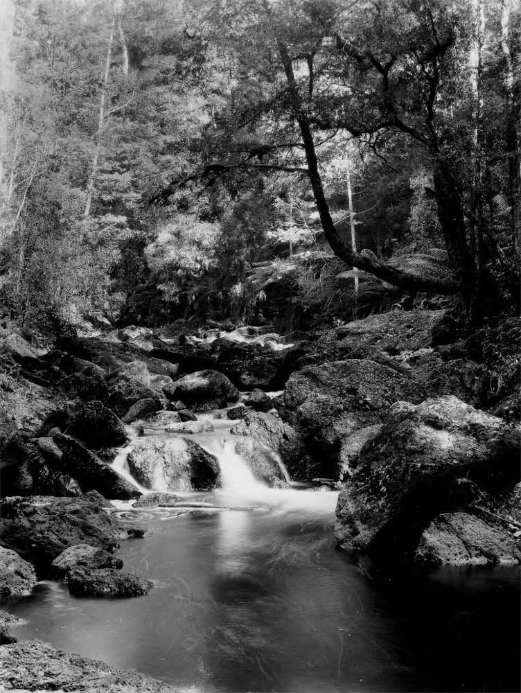
Bott Gorge, Tasmania
Early in 1851, William Dean and his brother-in-law Benjamin Cocker made a voyage from Launceston along the North West Coast to buy split palings for the Melbourne market where Cocker had just established an importing business. They decided to return to Launceston overland. Following the Don River inland, they came to Bott Gorge (just off the Sheffield Main Road, opposite Acacia Hills) where they found two timber workers named Powell and Ayres.
Invited to shelter overnight in their hut, the travellers were struck by the strange appearance of the flames in their fireplace – the timber workers were burning coal. Next morning, Dean and Cocker offered the splitters five sovereigns to show them where this coal came from and were led to a nearby outcrop. This discovery of coal, within the present Kentish Municipality, was the first find of this mineral on the NW Coast. It set off the coal rush to the Mersey estuary. Soon coal was discovered in several other places. Hundreds of new settlers arrived, small townships came into existence, all of which changed the entire history of the Mersey River and Kentish districts.
The two merchants hurried back to Launceston with their coal samples and quickly organised a syndicate of business men who formed The Mersey Coal Company. By June 1851, they had purchased 1,700 acres of land covering the coal field, and by Sept 1851, Benjamin’s brother David Cocker and William Dean became the first settlers at Spreyton. They purchased two river frontage blocks at Dean’s Point (now Woodrising Golf Course) where they erected a jetty. On one occasion, David Cocker almost lost his life crossing the cold, fast-flowing Mersey River at Kimberley’s Ford. He and his horse were carried down river, but fortunately when thrown up against a bank, Cocker was able to hang on and eventually climbed out.
While William Dean concentrated on developing the mine at Bott Gorge, David Cocker set about building the first steam driven sawmill on the coast, at the base of the Don Tier (now Jowetts hill) about 2 ½ miles inland from Dean’s Point. It was close to the present Spreyton Cider Factory from where a wooden tramway was constructed back to Dean’s Point over what was first called Coal Mine Flat, now the Sheffield Main Road. It carried both coal from Bott Gorge and sawn timber from the mill.
At Bott Gorge, the new Launceston syndicate found three beds of coal, one in a tributary of the Don River, they called Coal Creek, which rises in the slopes of Acacia Hills and crosses the Sheffield Main Road half way along the straight. The Mersey Coal Company purchased a powerful steam engine, sought miners from England, built a series of accommodation huts and commenced a shaft which eventually went down 300 feet. The coal mining prospects were so exciting that the Governor, Sir William Denison, visited Bott Gorge in Feb 1853 to see the first six bullock-dray loads of coal, to leave for Dean’s Point jetty, to be shipped to Launceston. But the Company’s operation began in such an extravagant and wasteful way that William Dean withdrew from the syndicate and commenced mining on his own. Visiting the Bott Gorge mining camp in Dec 1854, a Wesleyan minister preached to 30 adults and 40 children. The Company continued for a couple of more years, but the narrow coal seams were full of faults and after spending nearly £20,000, the mine ceased work in 1857.
Text: Alan Dyer OAM
Read more
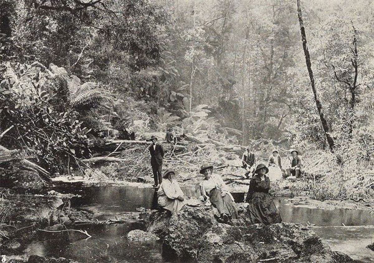
Around the turn of the 20th century, the Latrobe Tourist and Improvement Association established what it called "a delightful picnic resort at Bott Gorge, somewhere close to where coal had been found and mined. The offical opening of the picnic grounds was recorded in the TAHO Weekly Courier in 1919 but since then there is no record of what happened to it, or why it no longer exists today.
A suggested dam site
In July 1953, a Mr J.L. Fowler was commissioned to find possible sites for the construction of a dam for a projected gravitational water supply for Devonport. Three sites were suggested, and Geologist Terence Hughes was called in to assess the propsed sites from a geological point of view. The three sites were situated on the Don River; the first where the Spreyton - Sheffield Road crosses the river, the second at the entrance to Bott's Gorge, about three quarters of a mile below the crossing, and the third about a mile and a half (approx. 2.4 km) above the crossing.
Hughes, in his report, said, "The Don River, in this locality has cut down about 400 feet into the general plateau level, but it is still from four to five hundred feet above sea-level and genercllly flowing with quite a strong velocity. Where the river has cut into hard conglomerates the banks are steep (generally 200 to 300 slopes) and close together but where it cuts into Permian Rocks and limestone the valley widens considerably and areas of alluvial flats occur.
The first site is where the Spreyton-Sheffield road crosses the Don River, which lies about a kilometre upstream from Bott Gorge. Of this site, Hughes reported that "holes sunk to 13 feet on either side of the river show that the rock on which a dam would be constructed here is Permian Karine Sandstone. This appears to be a weak porous rock which, when exposed to the air, rapidly disintegrates. This same rock would underlie most of the basin behind this dam, except for patch ot limestone to the west ot the basin." For this reason, he rejected the site as suitable.
Of the second site (Bott's Gorge), Hughes said, "The No. 2 site appears to be ideal for the actua1 construction of a dam as it would be between two steep conglomerat walls and the conglomerate is very hard and rock. Smooth faces of rock in the Bott Gorge sug est a fault but the conglomerate ppears to be solid enough across the stream bed. However, some of the same objections to the basin might be made as in the No. 1 project as, although a littl lower, much of the basin would be the same as No.1. He concluded that of the three sites, the third would be the best from a geological point.
Henry Bott
The name of the gorge recalls Henry Bott, an early settler in the area. There are a number of Henry Botts who lived in the Latrobe area, so it is impossible to say with any degree of accuracy which one the gorge's name recalls. As Bott's Gorge was recorded in 1851 as the site of the coal seam find in the gorge, the most likely "Henry Bott" was one who came to Van Diemen's Land as a convict on the Runnymede, arriving in Hobart Town on 28th March 1840. Henry was aged 14 when indicted for stealing a pair of boot, value 8s., the goods of Charles Edward Kendall. Previous convictions were 3 months for stealing iron pots and 6 weeks for stealing meat.
Because of his age, Henry was sent to Point Puer near Port Arthur where he served out a large part of his 7 year sentence. He gained his certificate of freedom on 9th February 1846, and sailed to Melbourne from Hobart on the Scotia. Within four years he was back in Tasmania and had married Catherine Gadd of Port Sorell. The coal seam was discovered in 1851, a year after he was married. Henry and Catherine had 8 children from 1860-75. In 1868, he was recorded as being both a farmer and insolvent, and living at North Down. Northdown is a locality and small rural community in the local government area of Latrobe near Port Sorell. The name "Northdown" was given to a large house built in the area for Mr. Edward Curr, manager of the Van Diemen's Land Co., in 1827.
Convict record
Acacia Hills
Bott Gorge falls within the boundaries of Acacia Hills, a locality and small rural community in the local government area of Kentish. It is located about 16 kilometres south of the town of Devonport. The 2016 census determined a population of 623 for the state suburb of Acacia Hills. The Don River, forms the south-western and western boundaries. Bonneys Tier Forest Reserve is in the south-east of the locality.